Frontenac Provincial Park is a 52-square-kilometre region of the Frontenac Axis, the southern arm of the Canadian Shield. Established in 1974, it offers 48 campsites accessible by either well-maintained trails or canoe. Just slightly over two hours south-west of Ottawa, the park has a mixture of trails with a wide range of difficulty.
Table of Contents
- Intro: The Park, Weather, and GPS
- Planned Route
- The Hike: Scenery, Terrain, and Wildlife
- GPS Track Log: Successes and Mistakes

Intro: The Park, Weather, and GPS
I was recently invited along on a weekend hiking trip through the Frontenac area with three other adults. In our case we got to the park around noon on Friday, April 30, and made it back to our car by mid-afternoon on Sunday, May 2. The weather was forecast to be mostly rain, but instead we were given clear skies and warm temperatures. A thunderstorm drenched us for an hour on Saturday night, but we had already made camp and it didn’t affect us.
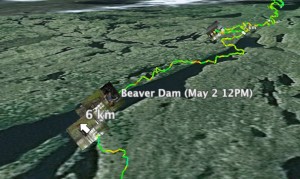
This was my first time to the Park, and I wanted to use my BlackBerry’s GPS to record our track so I could review it on a computer once I got home. I wrote a short program in Java that polled the GPS receiver every so often, and saved its coordinates to a log file, along with its current altitude and speed. See the attached Google Earth KMZ file for the final result - at the very least the view is interesting, and it is easily useful for anyone planning a similar route.
Planned Route
As I mentioned above, we arrived at the Park’s main office at noon the first day, and paid our entrance fees. As of our trip each adult cost $11 per night, but for current pricing please visit the Park’s website. Campsites are not available for pre-registration, and are run on a first-come-first-served basis. Our relatively early arrival compared to a typical weekend meant that we got our choice of sites.
We chose our route the day of, based on the previous experience of a person in our group. This is what we agreed on:
- Day/Leg 1: hike to Campsite #1 (~9 km)
- Day/Leg 2: hike to Campsite #13 (~10 km)
- Day/Leg 3: hike back to car (~10 km)
The Hike: Scenery, Terrain, and Wildlife
Leaving our car at Arab Lake Parking Lot, we set out towards Campsite #1. The first leg was the toughest, often cutting directly across contour lines on the map. Getting halfway along the first leg took about two thirds of the time we spent hiking that day. After reaching a certain cliff by a large lake (possibly at 44.50370, -76.51545 but I can’t be sure), the rest of the trail becomes much simpler. The slopes die off into a series of grassy fields that make for easy hiking, albeit without shade. We reached camp at 4:30pm, after a total of exactly four hours. There were numerous black flies that made for an uncomfortable evening, but they disappeared at dusk. Side note: we were advised that it would take five hours to arrive at camp. Side side note: we were an adult-only group, so your mileage will vary.
If you don’t mind me adding another paragraph in here, I’d like to mention the campsites themselves. Every one we saw (#1, #3, #5, #13) was well maintained and provided sandy, elevated, 14-square-foot tent bases. There is also a fireplace with a grill at each site, as well as a latrine.
At 9:15 the next morning (Saturday) we strapped on our packs and headed out of camp towards the main trail that would lead us to #13. Unfortunately, we all missed the sign and, being unsure how far back the entrance to the trail was, sped 600 meters the wrong way before turning around. Lesson learned (or so we thought): read every sign carefully.
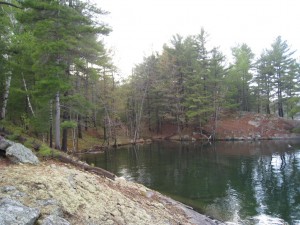
This portion of the trail is filled with beautiful scenery, including waterfalls. At one point the trail winds along the top of an elevated ridge between two lakes. There are beaver dams that hold massive amounts of water back as we walk along, several feet under the water level. Trillium flowers can be seen occasionally as well as small animals such as chipmunks. In fact, as we descended one hill, one of us nearly put his hand on a black rat snake that was lying in a tree.

After about four hours of hiking we reached Campsite #5, which includes a sandy beach on the north-east end of Big Salmon Lake. We had less than 2.5 kilometres left, but there was a threat of a thunderstorm so we continued on after refilling our water bottles. With just 1.3 klicks to go, we reached the turnoff for Campsite #13. It would seem we did not learn our lesson from the same morning, because we glossed over the sign and once again went the wrong way. Fortunately this time we realized our mistake after only 400 meters, and found our way to camp. Total time en-route that day, excluding mistakes, was five hours.
Campsite #13, being 1.3 kilometres off the main trail, would seem rather out of the way, but actually both the trail and the site itself make up for the distance. We were also favoured by an absence of bugs - perhaps they were frightened off by the impressive thunderstorm that rolled through just after we made camp.
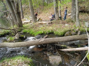
After making a late start to our third day, Sunday, we retraced our errant steps from the evening before, but this time knowing they were in the right direction. Between two and three kilometres out, we met with an old logging road that let us move quickly. The road eventually reverted to a trail, but one that was gentler than the trails from the previous days. We quickly made Campsite #3 after just three hours, and ate lunch by the southern end of Big Salmon Lake. Despite the time of year, a couple of us went swimming. Honestly, “swimming” is the word for it, as the pictures prove!
An hour later we were back at the car, turning our cell phones on again, and shedding our walking sticks. Fifteen minutes later our legs were doing nothing yet we were moving North along Bedford Road, and the trip was behind us.
GPS Track Log: Successes and Mistakes
When we first set out from our car, I told my BlackBerry to record our location every ten minutes to save battery. Unfortunately, that interval is long enough for the GPS chip to “cool down” between updates, causing sporadic logging. The upshot is that that first leg was recorded using only two points, which is pretty horrible. I replaced that leg with a simple straight line when I manipulated the data at home.
That problem did not happen for the rest of the trip, since I discovered that polling the GPS takes virtually zero battery, and I could afford to set the refresh interval at five seconds. Five seconds is so short that the resulting high-resolution log is fun to look at.
You will notice a file below entitled Frontenac_Hiking_Spring_2010.kmz. It is a Google Earth file containing our track, campsites, photos, and a narrated tour. It is important to note that it does not internally contain any large files, for instance the the photos and the tour audio. Those are hosted on this website, which means that in order to get the full experience you will need an active Internet connection.

Cheers!
Download the GPS log in KMZ format: Frontenac_Hiking_Spring_2010.kmz (100 KB)